Telecommunications companies face enormous pressure right now. 5G rollouts demand more towers, more fiber, and faster timelines. Rural broadband expansion requires precise route engineering through difficult terrain. And the existing tower inventory needs constant inspection and maintenance to keep networks operational.
Traditional survey methods can't keep up. Sending ground crews to walk fiber routes, climb towers, and manually document infrastructure conditions is slow, expensive, and creates real safety risks. That's exactly why a growing number of telecom operators, tower companies, and network engineering firms are turning to LiDAR scanning services powered by drones.
LiDAR (Light Detection and Ranging) isn't new, but the combination of high-density laser scanners with commercial drone platforms has changed what's possible. A single drone flight can capture millions of georeferenced data points, producing 3D models and point clouds that give engineers the spatial accuracy they need to make confident decisions about network infrastructure.
At AeroSpect NY, we've seen firsthand how this technology is reshaping telecom workflows. Here's a closer look at why it's happening, how the process works, and where LiDAR delivers the most value for telecommunications projects.
The Problem with Traditional Telecom Surveys
Before understanding why LiDAR matters for telecom, it helps to know what it's replacing. Traditional infrastructure surveys typically involve:
- Ground crews walking proposed fiber routes with handheld GPS units and measuring equipment, a process that can take weeks for a single corridor
- Tower climbers ascending structures to take measurements, photograph equipment, and assess structural conditions, often in challenging weather
- Multiple site visits to re-verify data that was incomplete or inaccurate the first time
- Manual data entry and hand-drawn documentation that introduces human error and doesn't integrate easily with modern design tools
These methods worked when network expansion happened at a slower pace. But with 5G deployment accelerating and regulatory deadlines tightening, telecom companies need a way to collect accurate spatial data faster, safer, and at scale. That's where drone-enabled LiDAR comes in.
How LiDAR Works for Telecommunications Applications
LiDAR sensors emit thousands of laser pulses per second, measuring the precise distance to every surface those pulses hit. When mounted on a drone, the sensor captures data from above as the aircraft follows a pre-planned flight path. The result is a dense point cloud, a three-dimensional representation of the scanned area accurate to within centimeters.
For telecom projects, this data gets processed into several deliverable formats:
Digital Terrain Models (DTMs)
Bare-earth elevation data that shows slopes, drainage patterns, and grade changes critical for fiber route engineering.
Digital Surface Models (DSMs)
Elevation data that includes vegetation, buildings, and other above-ground features that affect line-of-sight and signal propagation.
3D Point Clouds
Raw spatial datasets that can be imported into CAD, BIM, or GIS platforms for engineering analysis and design.
Orthomosaic Maps
Georeferenced aerial imagery stitched together for visual context alongside the LiDAR data.
The key advantage over traditional surveying? Engineers get a complete spatial picture of the environment, not just spot measurements taken at a handful of locations.
Fiber Route Planning with Precision Terrain Data
Laying fiber optic cable is one of the most capital-intensive parts of network expansion. A miscalculation in route planning can mean rerouting around obstacles that should have been identified earlier, sometimes adding months and hundreds of thousands of dollars to a project budget.
Drone-mounted LiDAR gives route engineers the data they need before construction begins:
- Pole-to-pole measurements: Exact distances between utility poles, along with pole heights and lean angles
- Obstruction identification: Trees, guardrails, signage, existing infrastructure, and other physical barriers mapped with centimeter accuracy
- Terrain analysis: Slopes, elevation changes, and drainage patterns that affect cable placement and equipment installation
- Right-of-way documentation: Precise spatial records of existing utility corridors and easement boundaries
A project that would take ground crews weeks to survey can often be captured by a drone pilot in days. And because LiDAR penetrates vegetation canopy, the data reveals terrain features that ground-level photography would miss entirely.
AeroSpect NY's high-density LiDAR scanning captures these datasets with the accuracy that fiber engineering demands, delivered in formats compatible with the CAD and GIS platforms telecom engineers already use.
Smarter Tower Assessment and Placement Analysis
Deciding where to place a new cell tower involves more than finding available land. Engineers need detailed spatial data about the surrounding environment to determine signal coverage, structural requirements, and potential interference.
LiDAR provides the measurements that make these decisions possible:
| Data Point | Manual Survey | Drone LiDAR |
|---|---|---|
| Terrain elevation mapping | Spot measurements at selected points | Continuous coverage across entire site |
| Tree and vegetation heights | Visual estimates from ground level | Precise measurements from canopy top to ground |
| Surrounding building heights | Requires separate building surveys | Captured automatically in same scan |
| Data collection time (typical site) | 2 to 5 days | 2 to 4 hours |
| Personnel safety risk | Moderate to high (climbing, rough terrain) | Minimal (remote operation) |
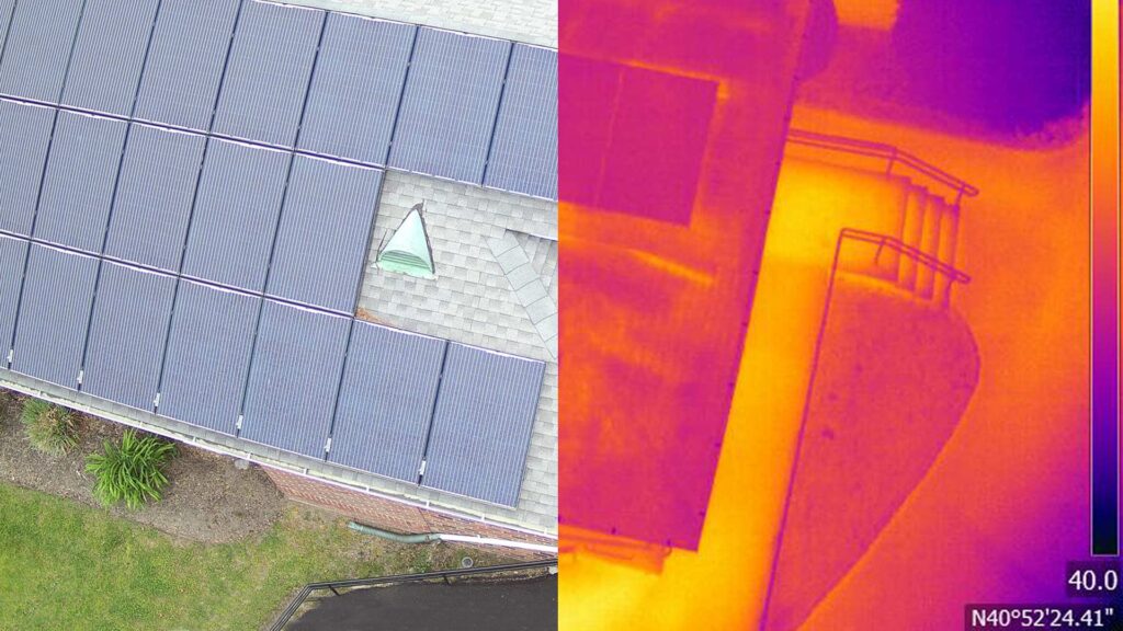
For existing tower inspections, drone LiDAR captures structural dimensions, equipment clearances, and mounting positions without anyone having to climb. This data feeds directly into structural loading analyses and modification plans, saving days of field work per tower.
These capabilities overlap with AeroSpect NY's broader aerial inspection services, where drones equipped with cameras and sensors provide safe, efficient assessments of hard-to-reach assets across multiple industries.
Speed and Scalability That Manual Methods Can't Match
One of LiDAR's most practical advantages for telecom is throughput. Consider the numbers:
This scalability matters because telecom projects rarely involve a single tower or a short fiber run. Companies routinely manage portfolios of thousands of towers and hundreds of miles of fiber routes. The ability to capture consistent, high-quality data at volume is what makes drone LiDAR a practical solution, not just a technological novelty.
The workflow from scan to deliverable follows a structured process:
- Planning Site review, flight plan design, and coordination of any required FAA authorizations
- Capture Drone flights with LiDAR sensors, supported by ground control points for georeferencing accuracy
- Processing Point cloud generation, noise removal, classification, and data stitching
- Quality Assurance Accuracy verification against control points and deliverable review
- Delivery Final datasets in standard formats (.LAS, .LAZ, DEM, DTM, DWG, GeoTIFF) ready for engineering use
When LiDAR Is the Right Tool and When It Isn't
Not every telecom data collection task calls for LiDAR. Understanding when to use it, and when another approach works better, is important for controlling project costs and getting the right deliverables.
LiDAR Is the Best Fit When You Need:
- Precise terrain models for fiber route engineering
- 3D tower measurements for structural analysis
- Obstruction mapping over large areas
- Digital twins of infrastructure assets
- Elevation data for signal propagation modeling
- Vegetation encroachment analysis along corridors
Consider Alternatives When:
- You only need close-up photos of equipment labels or connectors
- The project scope is a single pole or small area
- Visual-only asset documentation is sufficient
- Budget constraints favor simpler RGB drone photography
- Physical testing or sampling is required
In many cases, the best approach combines LiDAR with standard aerial imagery. AeroSpect NY regularly pairs LiDAR scans with high-resolution photography and thermal imaging to give clients a complete picture of asset conditions. Our full range of drone inspection services includes options for every project scope and budget.
LiDAR Beyond Telecom: Cross-Industry Applications
The same LiDAR technology transforming telecommunications is delivering value across multiple industries. If your organization handles physical infrastructure, there's a strong chance LiDAR can improve your data collection processes.
Building Facade Inspections
LiDAR combined with drone photography supports detailed building facade inspections, capturing structural geometry alongside visual condition data for regulatory compliance and maintenance planning.
Accident Forensics
When incident scenes need precise spatial documentation, drone-based accident forensics with LiDAR creates accurate 3D records that support insurance claims and legal proceedings.
Construction Monitoring
Periodic LiDAR scans track construction progress against design plans, enabling volumetric analysis and clash detection throughout the project lifecycle.
Infrastructure Assessment
Bridges, highways, and utility systems benefit from the same aerial inspection approach that's making telecom surveys more efficient.
Regulatory Compliance and Safety Considerations
Operating drones for commercial LiDAR scanning requires more than just good equipment. FAA Part 107 certification is mandatory for all commercial drone pilots. In urban environments like New York City, additional authorizations and coordination with local authorities are often required.
AeroSpect NY manages these requirements as a standard part of every engagement:
- FAA Part 107-certified pilots with experience operating in controlled airspace
- Airspace authorization coordination, including LAANC approvals for operations near airports
- Site safety planning that accounts for ground personnel, public areas, and operational hazards
- Equipment redundancy with advanced navigation, obstacle avoidance, and fail-safe return protocols
For telecom companies operating in cities governed by strict inspection regulations, like NYC's Local Law 11, drone-based LiDAR also provides the documentation quality and repeatability that compliance programs demand.
Organizations that want to build internal drone capabilities or supplement their own fleet can also explore AeroSpect NY's drone rental programs, which include access to professional LiDAR-equipped systems with optional pilot support.
What to Look for in a Telecom LiDAR Provider
Not all drone LiDAR services are created equal. Telecom projects have specific requirements that demand a provider with the right combination of technology, experience, and operational capabilities. Here's what matters most:
Equipment Quality
High-density laser scanners that capture enough points per second to produce the resolution your engineers need. Consumer-grade systems won't cut it for infrastructure engineering.
Deliverable Flexibility
The ability to produce datasets in the formats your engineering teams use, whether that's .LAS point clouds, CAD-ready drawings, GIS layers, or BIM-compatible models.
Regulatory Knowledge
Experience navigating FAA requirements, urban airspace restrictions, and local permitting, especially if your projects include sites in complex environments like New York City.
Scalability
A provider that can handle one tower inspection this month and a 100-mile fiber route survey next month without compromising data quality or turnaround time.
AeroSpect NY has operated at the intersection of advanced drone technology and infrastructure inspection since 2018, building the equipment portfolio, pilot expertise, and data processing workflows that telecom projects require.
The Shift Toward Data-Driven Network Management
The trend toward drone-powered LiDAR in telecommunications isn't temporary. It reflects a broader industry shift toward data-driven infrastructure management. Tower companies are building digital asset libraries, complete with 3D models and point cloud archives, that allow them to manage thousands of sites remotely. Fiber network operators are using terrain models to optimize route designs before a single trench is dug.
As LiDAR sensor technology continues to improve, with better resolution, longer range, and faster processing, the gap between drone-collected data and traditional survey methods will only widen. Organizations that adopt these tools now position themselves to build networks faster, maintain them more efficiently, and make better-informed capital decisions.
For telecom companies evaluating whether LiDAR is right for their next project, the starting point is straightforward: define the outcome you need, then work backward to determine the best data collection method. In most cases involving spatial measurement, terrain analysis, or structural documentation, LiDAR will be the most accurate and cost-effective option available.
Frequently Asked Questions: LiDAR for Telecommunications
LiDAR is used in telecommunications to create precise 3D terrain models for fiber route planning, assess tower placement by measuring elevation and obstructions, inspect existing tower infrastructure for maintenance needs, and generate digital twins of network assets for remote management and long-term planning.
Drone-mounted LiDAR captures data from above, making it ideal for scanning large fiber routes, tower tops, and hard-to-reach infrastructure across wide areas. Ground-based LiDAR uses tripod-mounted scanners for detailed measurements of structures and interiors. Many telecom projects benefit from combining both approaches for comprehensive spatial data. AeroSpect NY offers both drone-based and ground-based LiDAR scanning to match each project's requirements.
LiDAR scanning can replace many aspects of manual tower inspections, especially those involving climbing for structural measurements, clearance verification, and equipment mapping. Drone-mounted LiDAR captures detailed 3D point clouds without putting personnel at height. However, certain hands-on tasks like connector testing or equipment replacement still require physical access.
Professional drone LiDAR systems with ground control points can achieve accuracy within 1 to 3 centimeters. This level of precision is sufficient for fiber route engineering, tower structural analysis, obstruction mapping, and regulatory compliance documentation in the telecommunications industry.
Ready to Bring LiDAR to Your Telecom Project?
Whether you're planning a fiber route, assessing tower sites, or building a digital asset library, AeroSpect NY's drone-enabled LiDAR scanning delivers the accuracy and speed your engineering teams need. Let's talk about your project goals and build a data capture plan that fits.