Cities are growing faster than ever. The United Nations estimates that 68% of the world's population will live in urban areas by 2050, putting enormous pressure on planners, engineers, and developers to build smarter, safer infrastructure. For professionals working in dense metropolitan environments like New York City, outdated surveying methods simply can't keep up with the complexity and speed of modern development.
That's where LiDAR (Light Detection and Ranging) enters the picture. This remote sensing technology uses rapid laser pulses to measure distances, generating dense 3D point clouds that represent buildings, terrain, and infrastructure with millimeter-level precision. When mounted on drones, LiDAR becomes an even more powerful tool, capable of scanning vast urban areas quickly, safely, and at a fraction of the cost of traditional survey methods.
At AeroSpect NY, we've seen firsthand how LiDAR scanning services are reshaping how cities are planned, monitored, and maintained. This blog explores the technology behind LiDAR, its growing role in urban planning, and why it matters for architects, engineers, and facility managers across New York and beyond.
What Is LiDAR and How Does It Work?
LiDAR works by emitting millions of laser pulses per second toward surfaces and recording the time each pulse takes to return. These measurements create an extremely detailed three-dimensional map called a point cloud. Unlike standard photography, LiDAR captures precise spatial geometry, including elevation changes, surface contours, and structural dimensions.
High-density laser scanners used in professional applications emit enough pulses to capture fine details that would be invisible to conventional survey instruments. The resulting data can be converted into 3D models, contour maps, and digital twins compatible with CAD, BIM, and GIS software.
What makes drone-mounted LiDAR especially valuable for urban planning is its ability to:
- Cover large areas quickly: A single drone flight can scan an entire city block in minutes, compared to days or weeks with ground-based crews.
- Operate in challenging conditions: LiDAR works effectively in low-light environments, at night, and can penetrate vegetation canopies to map the terrain below.
- Access hard-to-reach locations: Tall structures, active construction zones, and hazardous sites that would require scaffolding or rope access for traditional methods are easily scanned from the air.
- Produce survey-grade accuracy: Millimeter precision supports everything from structural analysis to regulatory filings.
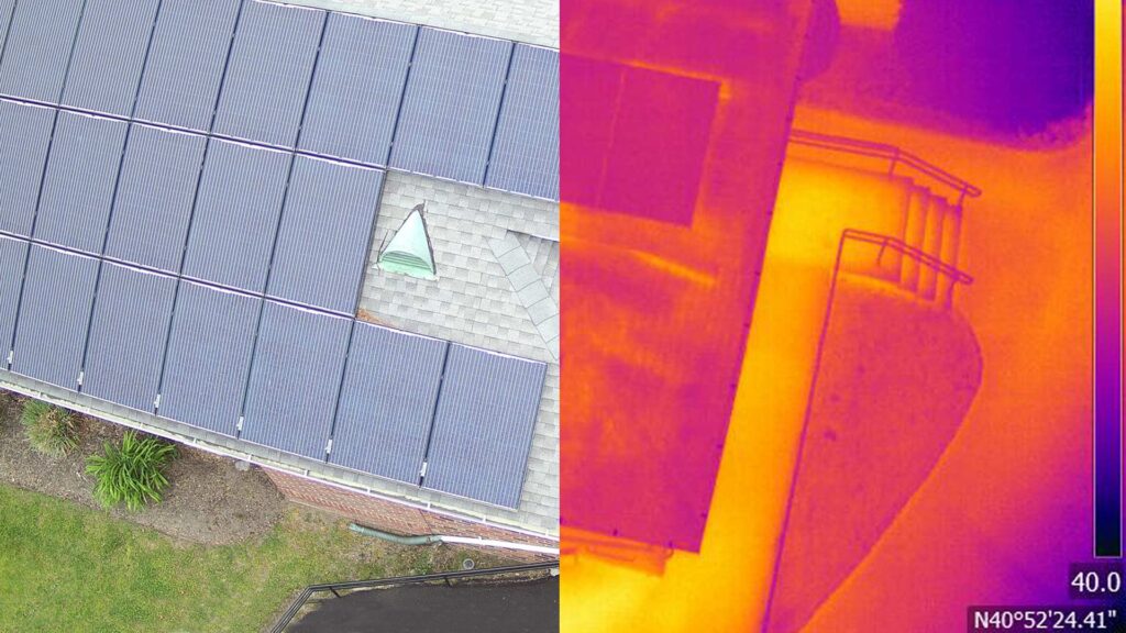
Drone-captured thermal and visual imagery used in aerial assessments.
Building Accurate 3D City Models with LiDAR
One of the most significant applications of LiDAR in urban planning is the creation of detailed 3D city models. These digital representations go far beyond simple maps. They capture building heights, street widths, terrain elevation, vegetation coverage, and utility infrastructure with remarkable fidelity.
City planners and decision-makers use these models to:
- Visualize proposed developments in the context of existing infrastructure, identifying potential conflicts before construction begins.
- Analyze sunlight and shadow patterns across neighborhoods, which influences zoning regulations and residential quality of life.
- Simulate traffic flow and pedestrian movement to optimize transportation networks and public transit routes.
- Plan green spaces and urban canopy management using precise vegetation data captured by LiDAR's ability to penetrate tree cover.
- Monitor construction progress by comparing periodic LiDAR scans against approved design plans.
In a city like New York, where every square foot of real estate carries enormous value, the precision of LiDAR-derived 3D models helps stakeholders make informed choices that reduce project risk, minimize costly redesigns, and accelerate approval timelines.
AeroSpect NY's high-density LiDAR scanning produces point cloud data that integrates directly with GIS and BIM platforms, giving architects and engineers a complete spatial picture they can work with immediately.
Identifying Infrastructure Risks Before They Become Emergencies
Urban infrastructure ages constantly. Concrete cracks, steel corrodes, and foundations shift over decades of exposure to weather, vibration, and heavy use. The challenge for engineers and facility managers is catching these problems early, before a minor crack becomes a structural failure or a facade collapse injures someone on the street below.
LiDAR technology plays a critical role in proactive infrastructure assessment. Here's how:
Detailed Structural Assessments
High-resolution 3D scans reveal surface deformations, misalignments, and deterioration patterns that aren't visible to the naked eye or through standard photography. Engineers can measure the exact dimensions of cracks, quantify material loss, and track how conditions change between inspections.
Monitoring Structural Health Over Time
By performing periodic LiDAR scans of the same structure, professionals can create a timeline of structural behavior. This data-driven approach identifies trends, such as gradual tilting or expanding fractures, that indicate developing problems before they reach critical thresholds.
Flood and Hazard Mapping
LiDAR's precise elevation data is essential for modeling flood zones, stormwater drainage patterns, and landslide-prone areas. City planners use these insights to direct development away from high-risk zones and to design drainage infrastructure that can handle extreme weather events.
Load-Bearing and Stress Analysis
When combined with engineering software, LiDAR data supports stress and load analysis for bridges, parking structures, and high-rise buildings. This information is vital for determining whether existing structures can safely accommodate renovation, additional floors, or changes in use.
For New York City building owners, this kind of analysis is directly relevant to Local Law 11 (FISP) compliance, where detailed facade documentation is required every five years. AeroSpect NY's drone facade inspection services combine high-resolution imagery with LiDAR data to give QEWIs the comprehensive visual and spatial documentation they need.
AeroSpect drone conducting an aerial inspection over the Williamsburg Bridge.
Designing Cities That Can Withstand Climate Change
Resilience isn't just a buzzword. For coastal cities like New York, rising sea levels, more frequent storms, and intensifying heat island effects are real threats that demand concrete planning. LiDAR provides the precise topographic and structural data planners need to design infrastructure that can absorb and recover from these stresses.
Here's where LiDAR contributes to resilience planning:
- Sea-level rise modeling: LiDAR's centimeter-accurate elevation data reveals exactly which areas, buildings, and infrastructure will be affected at various projected sea-level increases.
- Stormwater management: Detailed terrain models show how water flows across urban surfaces during heavy rainfall, enabling engineers to design retention systems that prevent flooding.
- Heat island analysis: LiDAR captures building heights and reflective surface data that, combined with thermal imaging from aerial inspection services, helps planners identify neighborhoods most vulnerable to extreme heat.
- Emergency response planning: 3D city models give first responders accurate spatial data for navigation, evacuation route planning, and resource staging during disasters.
Cities like Toronto have already used LiDAR to estimate stormwater flow through urban streets, calculate solar potential across land parcels, and assess emergency response times for high-rise buildings. New York City can benefit from the same approach, and the technology to make it happen is available right now.
Supporting Sustainable Urban Development
Sustainability goals require precise data. You can't optimize energy efficiency, reduce carbon footprints, or manage urban green spaces effectively without knowing exactly what you're working with. LiDAR delivers that baseline knowledge.
Solar Potential Assessment
By mapping building rooftops and calculating surface angles relative to sunlight exposure, LiDAR data helps developers and city agencies identify the best candidates for solar panel installations. This accelerates renewable energy adoption and reduces reliance on fossil fuels.
Urban Canopy and Green Space Management
LiDAR's ability to penetrate tree canopies and measure vegetation density provides essential data for urban forestry programs. Planners can track canopy coverage over time, identify areas where new planting would have the greatest cooling effect, and prioritize maintenance of existing green infrastructure.
Waste and Material Management
Volumetric analysis powered by LiDAR scanning measures stockpiles, excavated material, and construction waste with high accuracy. This helps construction managers minimize material waste and ensures accurate reporting for sustainability certifications.
AeroSpect NY's drone inspection services support these sustainability initiatives by providing the accurate spatial data that makes measurable progress possible.
Why Drone-Enabled LiDAR Changes the Game for Urban Projects
Ground-based LiDAR scanners have been around for years, but mounting these sensors on drones has expanded what's possible in urban environments. The combination of aerial mobility and laser precision addresses several persistent challenges in city planning and infrastructure management.
| Factor | Traditional Surveying | Drone-Mounted LiDAR |
|---|---|---|
| Speed | Days to weeks per site | Hours per site |
| Accuracy | Centimeter-level (varies) | Millimeter-level precision |
| Safety Risk | Requires personnel at heights or hazardous areas | Remote operation; no personnel exposure |
| Accessibility | Limited by scaffolding, cranes, or rope access | Reaches any elevation or angle |
| Data Density | Sampled measurement points | Millions of points per second |
| Disruption | Often requires road closures or building access | Minimal to no disruption |
| Cost | High labor and equipment costs | Significantly reduced project costs |
For professionals who need to assess a building facade, survey a construction site, or map a neighborhood for development, drone-enabled LiDAR compresses timelines and reduces costs without sacrificing the quality of data they rely on.
AeroSpect NY operates FAA Part 107-certified pilots who are authorized to fly in NYC's restricted airspace, ensuring that every drone-enabled LiDAR project is conducted safely and in full regulatory compliance. Whether you need drone-based or ground-based LiDAR scanning, our team tailors each project to your specific requirements.
Real-World Applications: How AeroSpect NY Applies LiDAR for Urban Clients
LiDAR's versatility means it serves a wide range of professionals and project types. Here are some of the ways AeroSpect NY applies this technology for clients working on urban planning and infrastructure projects:
- Building facade analysis: Combining LiDAR with drone facade inspections to produce precise 3D models that engineers annotate for Local Law 11 filings and maintenance programs.
- Construction progress tracking: Periodic scans that compare as-built conditions against design plans, catching deviations early and keeping projects on schedule.
- Bridge and infrastructure inspection: Aerial inspections that capture the underside of bridges, elevated highways, and utility structures without lane closures or heavy equipment.
- Accident scene documentation: Accident forensics using LiDAR to create precise spatial records of incident sites for insurance, legal, and regulatory purposes.
- Topographic mapping for development: Generating accurate terrain models that inform site planning, grading design, and environmental impact assessments.
- Historic preservation: Creating detailed digital records of heritage buildings and landmarks, preserving their exact geometry for future restoration work.
For organizations that need the equipment but prefer to manage flights internally, AeroSpect NY also offers drone and sensor rentals with optional pilot support.
Challenges and Considerations for LiDAR in Urban Environments
While LiDAR's capabilities are impressive, it's important to understand its limitations and the practical considerations involved in deploying it effectively in urban settings.
Initial Investment and Expertise
Professional LiDAR equipment and the software needed to process point cloud data represent a significant investment. Equally important is having trained personnel who can plan flights, calibrate sensors, and interpret results accurately. This is one of the primary reasons organizations partner with experienced providers like AeroSpect NY rather than building in-house capabilities from scratch.
Data Volume and Processing
A single LiDAR scan of an urban block can generate terabytes of data. Processing this volume into usable deliverables like 3D models, contour maps, and BIM-ready files requires specialized software and computational resources. AeroSpect NY handles this entire pipeline, delivering clean, actionable outputs in formats compatible with your existing workflows.
Regulatory Compliance in NYC
Flying drones in New York City requires FAA Part 107 certification, specific airspace authorizations, and compliance with local municipal regulations. AeroSpect NY manages all permitting and authorization requirements, ensuring every flight operates within legal boundaries.
Privacy and Data Governance
LiDAR data collected in public spaces can capture detailed environmental information that raises privacy considerations. Responsible data handling, clear governance policies, and transparent communication with stakeholders are essential parts of any professional LiDAR operation.
What's Next for LiDAR in Urban Planning?
The technology continues to advance rapidly. Here are several trends that will shape how LiDAR is used in urban planning over the coming years:
- AI-driven analysis: Machine learning algorithms will increasingly automate the identification of defects, structural changes, and anomalies in LiDAR point clouds, reducing the time between data capture and actionable insight.
- Real-time point cloud generation: Faster processors and improved sensors are making it possible to generate and visualize 3D models during the flight itself, enabling immediate decision-making on site.
- Lower hardware costs: As sensor technology matures, LiDAR equipment is becoming more accessible to smaller firms and municipal agencies with limited budgets.
- Integration with autonomous systems: LiDAR is already central to autonomous vehicle navigation, and this same technology will support autonomous inspection drones that can conduct scheduled scans without direct human operation.
- Expanded delivery applications: As drone regulations evolve, drone delivery services will use LiDAR-mapped corridors for safe, efficient route planning through urban airspace.
AeroSpect NY stays at the forefront of these developments, continuously investing in the latest equipment and training to ensure our clients benefit from the most advanced LiDAR capabilities available.