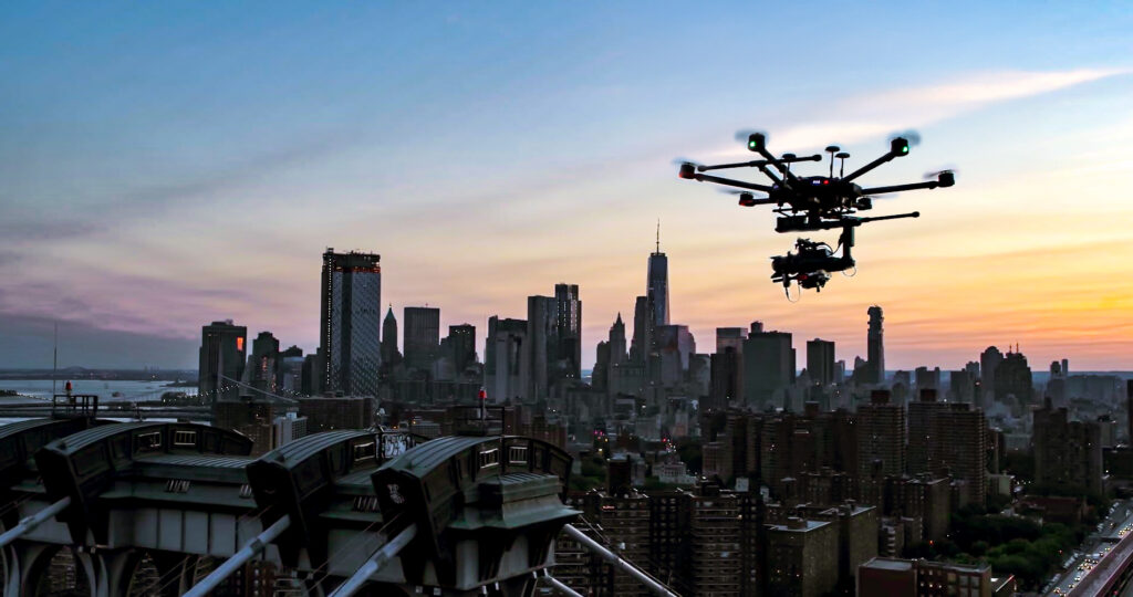
When most people think about drone inspections, they picture a pilot flying a quadcopter around a building facade. That image isn't wrong, but it only tells part of the story. The next evolution of unmanned aerial imaging is already here: fully automated drone inspections that combine pre-programmed flight paths with artificial intelligence to assess terminals, warehouses, infrastructure assets, and more.
For transport operators, facility managers, and infrastructure teams, automated inspections mean faster turnaround, better data, and lower costs. At AeroSpect NY, we've watched this transformation firsthand since 2018, and we've built our drone inspection services to stay at the forefront of what's possible.
This guide breaks down how drone automation works for terminal inspections, why logistics and infrastructure companies are adopting it, and where the technology is headed next.
Why Traditional Terminal Inspections Fall Short
Terminals, whether they're ferry docks, shipping ports, rail yards, or airport cargo facilities, present unique inspection challenges. These sites cover vast areas, operate around the clock, and contain thousands of moving assets that need to be tracked, verified, and assessed regularly.
Traditional inspection methods rely on a combination of manual walkthroughs, vehicle-based surveys, and stationary camera systems. Each approach has significant limitations:
- Time-intensive labor: Walking or driving through a terminal to locate, identify, and log assets can take hours per shift, slowing operations and tying up personnel.
- Safety risks: Inspectors working on foot near active loading zones, heavy equipment, and vehicle traffic face real physical danger.
- Inconsistent data: Manual documentation depends on the individual inspector's judgment, experience, and attention to detail, leading to gaps and variability.
- Limited visibility: Ground-level perspectives miss elevated structural issues, rooftop damage, and overhead obstructions that are only visible from the air.
- Operational disruption: Shutting down sections of a terminal for manual inspections interrupts workflows, delays shipments, and costs money.
These problems compound over time. A missed crack in a loading dock wall, an untracked trailer in the wrong bay, or an undetected thermal anomaly in a terminal roof can escalate into expensive repairs, safety incidents, or regulatory violations.
How Automated Drone Inspections Work at Terminals
Automated drone inspections remove the guesswork from terminal assessments. Instead of relying on a pilot to manually fly every pass, the process works through a structured, repeatable workflow:
1. Pre-Programmed Flight Planning
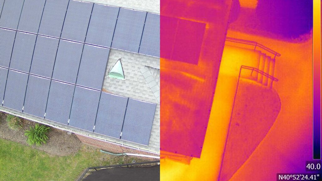
Before the drone leaves the ground, operators define the inspection area, set waypoints, configure altitude and speed parameters, and select the appropriate sensor payload. This could include high-resolution visual cameras, thermal imaging sensors, or LIDAR scanning equipment. Once the mission is programmed, the drone executes it with precision, covering every square meter of the designated zone.
2. Autonomous Data Capture
During flight, the drone captures thousands of georeferenced images, thermal readings, or 3D point cloud data along the programmed route. GPS coordinates and timestamps are embedded in every file, creating a complete digital record of conditions at the time of inspection. This consistency is something manual inspections simply can't match.
3. AI-Powered Processing and Analysis
After the flight, captured data is uploaded to specialized software platforms where AI algorithms process and organize the information. For logistics terminals, this might mean automatically identifying trailer positions and reading ID numbers. For structural inspections, the software can flag cracks, corrosion, water intrusion patterns, or thermal anomalies.
4. Actionable Reports and Integration
The processed data is compiled into structured reports, 3D models, or digital twins that integrate directly with terminal management systems, asset tracking platforms, or engineering review tools. Decision-makers get precise, visual, and verifiable information without waiting days or weeks for a manual write-up.
Real-World Impact: What the Numbers Show
The results of automated drone inspections aren't theoretical. Leading transport and logistics operators across Europe and North America have already documented substantial gains:
These savings multiply across hundreds or thousands of operations per year. For a large terminal operator managing millions of trailer movements annually, even small per-cycle improvements create enormous operational and financial advantages.
Beyond Logistics: Applications Across Industries
While transport terminals were among the first to adopt automated drone inspections, the same technology applies to a wide range of industries and asset types. At AeroSpect NY, our clients use these capabilities for everything from building facade inspections to post-incident documentation.
Building and Facade Assessment
New York City's Local Law 11 (FISP) requires periodic facade inspections on buildings six stories and taller. Automated flight paths let our pilots capture complete, repeatable coverage of every exterior wall, providing Qualified Exterior Wall Inspectors with high-resolution imagery and digital twins they can annotate, measure, and reference for compliance filings.
Accident Forensics and Scene Documentation
Accident forensics demand fast, accurate, and objective documentation. Automated drones can be deployed to capture comprehensive aerial evidence within minutes of arriving on scene. Every image is GPS-stamped and time-stamped, creating admissible records for insurance claims, legal proceedings, and forensic analysis.
Aerial Inspections for Infrastructure
Bridges, highways, rail corridors, and utility networks all benefit from aerial inspections that eliminate the need for lane closures, scaffolding, or rope access. Automated flights produce consistent datasets that can be compared over time to track deterioration and prioritize maintenance.
LIDAR Scanning for Precision Mapping
For projects requiring centimeter-level accuracy, aerial LIDAR scanning produces detailed 3D point clouds of terrain, structures, and assets. This data supports volumetric calculations, structural analysis, and engineering design in ways that traditional surveying methods can't replicate at scale.
Emergency and Disaster Response
When disasters strike and ground access is compromised, drone delivery platforms like the DJI FlyCart 30 can transport emergency supplies, medical equipment, and communications gear into affected areas. The same automated navigation technology that powers inspections also enables reliable point-to-point aerial transport in critical situations.
Choosing the Right Drone Platform for Automated Inspections
Not every drone is built for automated terminal and infrastructure inspections. The platform you choose needs to meet specific requirements for reliability, payload capacity, software compatibility, and regulatory compliance.
Here's what to look for:
| Feature | Why It Matters |
|---|---|
| SDK and API Access | Enables development of custom automated workflows tailored to your specific inspection needs and management systems |
| Multi-Sensor Payloads | Combined visual, thermal, and LIDAR sensors capture different data types in a single flight, reducing total flight time |
| Weather Resistance | Terminal and infrastructure inspections can't always wait for perfect conditions; IP-rated drones handle wind, rain, and temperature extremes |
| RTK GPS Positioning | Real-time kinematic GPS provides centimeter-level positional accuracy for georeferenced data and repeatable flight paths |
| Obstacle Avoidance | Automated flights near complex structures and active terminals require reliable collision prevention systems |
| Regulatory Compliance | FAA Part 107 certification, local airspace authorizations, and municipal permits are mandatory for commercial operations |
If you're not ready to invest in a full drone fleet, AeroSpect NY offers flexible drone and sensor rental options with optional pilot support. This lets you access enterprise-grade equipment for specific projects without long-term capital commitments.
How AI and Drones Work Together for Smarter Inspections
Automation alone doesn't make drone inspections intelligent. The real transformation happens when artificial intelligence processes the captured data and turns raw imagery into structured, actionable insights.
Here's how AI enhances each stage of the inspection workflow:
- Object recognition: AI algorithms identify specific assets like trailers, containers, vehicles, or structural components within captured imagery, eliminating manual counting and cataloging.
- Defect detection: Machine learning models trained on thousands of defect examples can flag cracks, spalling, corrosion, delamination, and water damage with higher consistency than visual-only human review.
- Change detection: By comparing datasets from multiple inspection cycles, AI highlights changes over time, catching slow-developing issues like settlement, material degradation, or vegetation encroachment before they escalate.
- Automated reporting: Instead of compiling reports by hand, AI generates organized documentation with annotated images, condition ratings, and recommended actions, cutting reporting time from days to hours.
This combination of automated flight and AI analysis is particularly powerful for organizations managing large asset portfolios. A property management firm responsible for dozens of buildings, or a logistics operator overseeing multiple terminals, can standardize inspections across all their sites with repeatable, comparable results.
Drone Inspections vs. Traditional Methods: A Direct Comparison
Understanding the concrete differences between traditional and drone-automated inspections helps decision-makers evaluate the right approach for their operations.
| Factor | Traditional Inspection | Automated Drone Inspection |
|---|---|---|
| Timeline | Days to weeks | Hours to one day |
| Safety Risk | High (scaffolding, rope access, active zones) | Minimal (remote operation) |
| Data Consistency | Variable (inspector-dependent) | High (repeatable flight paths) |
| Coverage | Limited to accessible areas | Complete aerial coverage including elevated/hard-to-reach zones |
| Operational Disruption | Significant (closures, restricted access) | Minimal (inspections during active operations) |
| Cost | Higher (labor, equipment, downtime) | Lower per inspection (reduced labor, no scaffolding) |
| Reporting Speed | Days to weeks | Same day to 48 hours with AI processing |
Getting Started with Automated Drone Inspections
Implementing automated drone inspections doesn't require rebuilding your entire operations workflow. For most organizations, the process follows a practical progression:
- Identify your highest-value use case. Start with the inspection task that costs the most time, money, or safety risk. For many clients, that's building facade inspections or large-site condition assessments.
- Partner with an experienced provider. FAA Part 107 certification is the baseline. You also need pilots experienced in complex airspace (especially in urban environments like NYC), proper insurance, and a track record with similar projects.
- Define deliverables upfront. High-resolution photos? 3D digital twins? Thermal analysis? LIDAR point clouds? Knowing what you need determines the sensor payload and processing pipeline.
- Run a pilot project. Test the automated approach on one site or asset before scaling. Compare results, timelines, and costs against your current method.
- Scale and standardize. Once validated, roll out automated inspections across your portfolio with consistent flight plans, data standards, and reporting formats.
AeroSpect NY has guided architects, engineers, facility managers, legal professionals, and government agencies through every step of this process since 2018. Our team brings hands-on experience with New York City's complex airspace regulations, Local Law 11 compliance requirements, and the specific demands of urban infrastructure assessment.
What's Next for Drone Automation in Inspections
The technology behind automated drone inspections is advancing quickly. Several developments are set to expand what's possible over the next few years:
- Dock-based autonomous operations: Drones that launch, fly, recharge, and store themselves from permanent docking stations will enable continuous, scheduled inspections without any human presence on site.
- Advanced AI defect classification: Machine learning models will become more specialized, able to distinguish between types of structural defects, estimate severity, and recommend specific repair actions automatically.
- Integration with digital twin platforms: Inspection data will feed directly into living digital twin models of buildings and infrastructure, creating always-current virtual replicas that support real-time maintenance decisions.
- Beyond Visual Line of Sight (BVLOS) operations: As FAA regulations evolve, drones will increasingly operate beyond the pilot's visual range, enabling inspection of long linear assets like highways, pipelines, and rail corridors in a single flight.
- Cargo damage detection: For logistics operators, the next frontier is automated visual assessment of cargo condition during loading and unloading, flagging damage before items leave the terminal.
These advances won't replace experienced inspection professionals. They'll give those professionals better tools, better data, and more time to focus on analysis and decision-making rather than data collection.
Frequently Asked Questions
Automated drone inspection uses pre-programmed flight paths and AI-powered data processing to assess terminals, buildings, and infrastructure without manual piloting for every pass. The drone captures high-resolution images, thermal data, or LIDAR scans along a set route, then software organizes and analyzes the results for faster, more consistent reporting.
Automated drone inspections typically reduce inspection timelines from weeks or months down to hours or a single day. In logistics terminals, companies have reported saving 15 minutes per loading cycle and reducing fuel usage by one ton per operation, with significant reductions in labor costs and CO₂ emissions.
Yes. Modern enterprise-grade drones equipped with visual, thermal, and LIDAR sensors are well-suited for inspecting large logistics terminals, ports, rail yards, and transport hubs. They can survey expansive areas quickly, identify asset positions, detect structural damage, and provide georeferenced data for management systems.
Industries that benefit most include transport and logistics, real estate and construction, energy and utilities, government infrastructure management, and insurance. Any sector that manages large physical assets or requires frequent condition assessments can realize major efficiency gains from automated drone inspections.
Start Today!
See How Automated Drone Inspections Can Work for Your Operations
Whether you manage building portfolios, logistics terminals, or critical infrastructure, AeroSpect NY's team can show you exactly what our drone inspection services deliver. Request a meeting to see sample deliverables, discuss your specific inspection challenges, and get a customized proposal.