Industrial facilities face a constant challenge: keeping critical infrastructure in safe, working condition without halting operations for extended periods. Traditional inspection methods often require scaffolding, rope access teams, or even helicopter surveys. Each of these approaches is expensive, time-intensive, and exposes workers to significant safety hazards.
That's why thermal drone inspections have become the preferred alternative for facility managers, engineers, and plant operators around the world. By combining unmanned aerial imaging with infrared thermography, drone inspection services can identify structural weaknesses, equipment failures, and hidden defects in a fraction of the time it takes conventional teams to set up their equipment.
At AeroSpect NY, we've seen this shift firsthand. Since 2018, we've been pioneering drone-based inspections in New York City, and the same principles that make aerial inspections effective for building facades apply directly to industrial settings. Here's a closer look at why thermal drones are changing how facilities are maintained, how the process works, and what you should know before scheduling your first flight.
What Is Aerial Thermography?
Thermography is the science of detecting heat signatures using infrared imaging. Every object emits thermal radiation, and a thermal camera translates that radiation into visible temperature data. When you mount a thermal sensor on a high-performance drone, you can capture that data from the air, covering vast areas quickly and safely.
This technique is sometimes called passive thermography because the drone doesn't emit any energy. Instead, it reads the radiated heat that objects naturally produce. The result is a thermal map that highlights temperature variations across surfaces, pipes, machinery, and structural components.
Unlike standard visual photography, thermal imaging reveals problems you can't see with the naked eye:
- Insulation failures where heat escapes through walls, roofs, or pipe lagging
- Moisture intrusion detected through temperature differentials in building envelopes
- Overheating equipment including electrical panels, motors, and bearings
- Blocked or leaking pipes that create abnormal heat patterns
- Structural anomalies such as delamination, voids, or cracks beneath surface materials
When integrated with LIDAR scanning, thermal data becomes even more powerful. Three-dimensional point clouds combined with thermal overlays give engineers a spatially accurate model that pinpoints exactly where a problem exists within a structure.
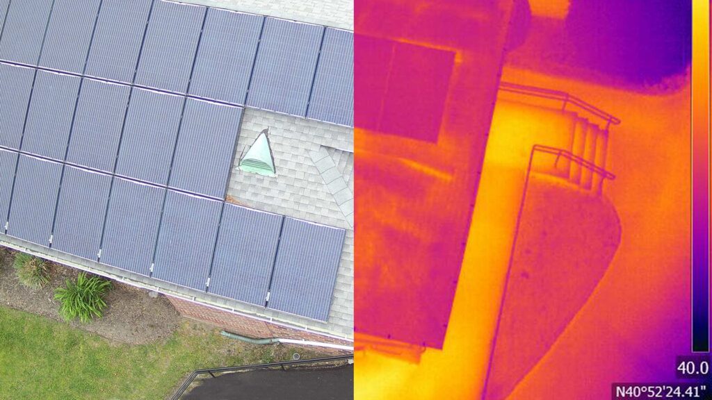
Thermal imaging compared to standard photography: the thermal view (right) reveals heat patterns invisible in RGB footage.
Why Industrial Facilities Need Thermal Drone Inspections
Industrial plants, refineries, and power stations contain thousands of components that must operate within precise temperature ranges. When something overheats, leaks, or corrodes, the consequences range from minor production slowdowns to catastrophic failures that endanger lives and cost millions.
Preventing Costly Shutdowns
One of the most compelling reasons to adopt drone-based thermal inspections is operational continuity. Traditional inspection methods frequently require facilities to shut down sections of a plant, sometimes for days or weeks. In oil and gas refineries, a single day of unplanned downtime can cost millions of dollars in lost production.
Thermal drones eliminate the need for these shutdowns in many cases. Because they operate remotely and don't require physical contact with the infrastructure being inspected, plants can continue running while the drone captures data overhead. This alone represents a significant return on investment.
Reducing Worker Risk
Confined spaces, elevated platforms, chemical exposure, extreme heat. Industrial inspection environments are inherently dangerous. Every time a technician climbs scaffolding or enters a tank for a visual check, there's an accepted level of risk involved.
Drone inspections dramatically reduce that risk. The pilot operates from a safe distance while the UAV navigates to elevated or hazardous areas that would otherwise require manual access. This safety advantage isn't just a nice benefit; it's becoming a regulatory expectation across multiple industries.
Catching Problems Before They Escalate
Perhaps the greatest advantage of aerial thermography is its ability to detect invisible problems. A flange that's running 15 degrees hotter than normal might look perfectly fine to the naked eye. But on a thermal image, that temperature spike stands out clearly, giving maintenance teams the early warning they need to schedule a repair before a small issue becomes a major failure.
How Thermal Drone Inspections Work: Step by Step
If you've never coordinated a thermal drone inspection, the process is more straightforward than you might expect. Here's what a typical engagement looks like, from planning through final report delivery.
1. Pre-Flight Planning and Site Assessment
Before any drone takes off, the inspection team conducts a thorough site assessment. This includes:
- Identifying the specific assets, systems, or structures to be inspected
- Reviewing facility layout and identifying potential flight obstacles (towers, flare stacks, power lines)
- Coordinating with plant safety teams to comply with internal protocols and applicable regulations
- Selecting the appropriate thermal color palette for the inspection objectives
- Determining optimal flight altitude, speed, and angle for data accuracy
This planning phase is critical. Flying too high reduces thermal resolution. Flying too fast can blur data points. And ignoring obstacles creates safety risks for the drone and surrounding personnel.
2. Flight Execution
A typical thermal inspection involves multiple flights. Most professionals run at least two passes with a standard RGB (visual) camera and one pass with a dedicated thermal sensor. The RGB footage provides visual context, while the thermal pass captures the infrared data.
Modern drones equipped with dual-sensor payloads can capture both simultaneously, reducing total flight time. The pilot follows pre-planned flight paths to ensure complete, systematic coverage of every target area.
3. Data Processing and Analysis
After the flight, raw thermal and visual data is processed using specialized thermography software. This step involves:
- Calibrating temperature readings against known reference points
- Generating thermal maps with color-coded temperature zones
- Overlaying thermal data on visual images for precise anomaly location
- Measuring temperature differentials across specific components
- Identifying patterns that suggest developing faults
4. Reporting and Recommendations
The final deliverable is a comprehensive inspection report that includes annotated thermal images, temperature measurements, identified anomalies, and prioritized maintenance recommendations. This report gives facility managers the actionable intelligence they need to make informed decisions about repairs, replacements, and scheduled maintenance.
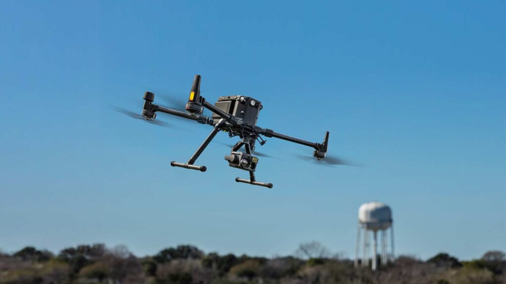
Advanced drone systems equipped with thermal and RGB cameras enable comprehensive industrial inspections from a safe distance.
Thermal Drones vs. Traditional Inspection Methods
Understanding the practical differences between drone-based thermal inspections and conventional approaches helps facility managers make better decisions about which method to use. Here's how they compare across key factors.
| Factor | Thermal Drone Inspection | Traditional Inspection |
|---|---|---|
| Time Required | 4–8 hours for most facilities | Several days to 2+ weeks |
| Operational Downtime | Minimal to none | Often requires partial or full shutdowns |
| Worker Safety | Remote operation; no scaffolding or confined-space entry | Manual access; elevated fall risk and chemical exposure |
| Data Quality | High-resolution thermal + RGB; georeferenced | Limited to visual observation; subjective reporting |
| Cost | Significantly lower per inspection cycle | High due to scaffolding, equipment, and labor |
| Repeatability | Automated flight paths ensure consistent coverage | Varies based on inspector experience and access |
| Hidden Defect Detection | Identifies subsurface and thermal anomalies | Limited to visible surface conditions |
The comparison makes it clear that thermal drone inspections don't just offer convenience. They fundamentally improve the quality, safety, and efficiency of the entire inspection process.
Where Thermal Drone Inspections Make the Biggest Impact
Thermal drone technology isn't limited to a single sector. From energy production to urban infrastructure, here are some of the most impactful applications.
Oil and Gas Refineries
Refineries contain complex networks of pipes, flare systems, heat exchangers, and storage tanks that all operate at elevated temperatures. Thermal drones can evaluate flare functionality, assess steam systems, identify weak points in structures, pinpoint failures in flanges, and reveal deformations before they lead to operational disruption or safety incidents.
Building Facade Inspections
In cities like New York, regulations such as Local Law 11 require periodic building facade inspections. Thermal imaging adds a powerful layer to these assessments by identifying moisture infiltration, air leaks, and insulation deficiencies that standard visual surveys miss. AeroSpect NY has been at the forefront of drone-based facade inspections in NYC since 2018.
Power Generation and Utilities
Solar panel arrays, electrical substations, wind turbines, and cooling towers all benefit from thermal monitoring. A single overheating cell in a solar installation can reduce output for an entire panel string. Thermal drones spot these issues across thousands of panels in hours.
Accident Scene Documentation
When industrial accidents occur, thermal drones provide rapid aerial documentation that captures conditions before evidence is disturbed. Accident forensics powered by drone technology delivers GPS-stamped, time-referenced imagery that supports insurance investigations, legal proceedings, and root cause analysis.
Construction and Infrastructure Monitoring
During construction, thermal imaging can verify insulation installation quality, identify water infiltration behind newly installed facades, and confirm that HVAC systems are performing as designed. When paired with LIDAR scanning, these inspections produce detailed 3D models that track construction progress with millimeter-level precision.
Key Factors That Affect Thermal Drone Inspection Accuracy
Not all thermal inspections produce equally reliable results. Several environmental and operational variables can influence data quality. Experienced operators know how to account for these factors before and during every flight.
Weather Conditions
Thermal inspections produce the best results under stable weather conditions. Direct sunlight heats exterior surfaces unevenly, which can mask or distort actual thermal anomalies. Rain, heavy cloud cover, and high winds also affect data collection. The ideal conditions are overcast skies with minimal wind and stable ambient temperatures.
Flight Altitude and Speed
Flying too high reduces the thermal camera's spatial resolution, making it harder to detect small anomalies. Flying too fast introduces motion blur. Professional operators find the right balance, typically flying as close and slow as safely possible, to capture the most detailed thermal data.
Color Palette Selection
Thermal cameras display infrared data using false-color palettes, since infrared energy is invisible to the human eye. Different palettes (white-hot, ironbow, rainbow) emphasize different temperature ranges. Choosing the right palette before the flight ensures that meaningful temperature differences are clearly visible in the final images.
Obstacle Awareness
Industrial environments are dense with vertical structures, power lines, gas venting systems, and moving equipment. Thorough pre-flight obstacle identification is essential for safe drone operation. This is where experienced, FAA Part 107-certified pilots make a critical difference.
Choosing the Right Drone Inspection Partner
The effectiveness of a thermal drone inspection depends as much on the team conducting it as on the equipment being used. When evaluating drone inspection providers, consider these factors:
- Industry experience: Look for a provider that has conducted inspections across multiple facility types and understands the specific challenges of your industry.
- Certified pilots: All commercial drone operations require FAA Part 107 certification at minimum. In complex airspace like New York City, additional authorizations and expertise are essential.
- Comprehensive service range: The best providers offer more than just thermal imaging. Look for a full suite of services that includes RGB photography, LIDAR scanning, digital twin creation, and detailed reporting.
- Equipment quality: Professional-grade drones with calibrated thermal sensors produce significantly better data than consumer-level equipment. Providers should also offer drone and sensor rental options for organizations that want flexibility without long-term ownership.
- Reporting capabilities: Raw images aren't enough. Your provider should deliver annotated, georeferenced reports with actionable findings and prioritized recommendations.
AeroSpect NY checks every one of these boxes. Since 2018, we've worked with some of the largest architecture, engineering, and facility management firms in the Northeast, building a track record of precision, reliability, and innovation that sets the standard for professional aerial inspections.
Beyond Inspections: Drone Technology for Emergency Response
Thermal imaging drones aren't the only UAV technology changing how industrial facilities operate. Drone delivery services are proving valuable in emergency and disaster response scenarios where ground access is limited or dangerous.
Heavy-lift drones like the DJI FlyCart 30 can transport essential supplies, replacement parts, and communications equipment directly to remote or damaged facility areas. In an emergency situation where roads are blocked or infrastructure is compromised, aerial delivery can be the difference between a rapid recovery and an extended shutdown.
This is especially relevant for industrial campuses spread across large geographic areas, offshore installations, and facilities in regions prone to severe weather events.
Frequently Asked Questions About Thermal Drone Inspections
What is aerial thermography and how does it work with drones?
Aerial thermography is the process of using thermal imaging cameras mounted on drones to detect heat signatures across surfaces. The drone's thermal sensor captures infrared radiation emitted by objects and converts it into a visual temperature map. This allows operators to identify hot spots, insulation failures, moisture intrusion, and equipment malfunctions without making physical contact with the structure being inspected.
How much time do thermal drone inspections save compared to traditional methods?
Traditional industrial inspections that require scaffolding, rope access, or helicopter flyovers can take anywhere from several days to two or more weeks. Thermal drone inspections typically complete the same scope of work in four to eight hours, depending on facility size and complexity. This represents a time reduction of up to 90% in many cases.
Can thermal drones detect problems that visual inspections miss?
Yes. Thermal cameras detect temperature variations invisible to the human eye or standard RGB cameras. This means they can identify issues like subsurface moisture, electrical faults, insulation gaps, pipe blockages, and overheating mechanical components before they become visible defects or cause operational failures.
Are thermal drone inspections suitable for all types of industrial facilities?
Thermal drone inspections are applicable across a wide range of industrial environments, including oil and gas refineries, power plants, manufacturing facilities, chemical processing plants, and large-scale commercial buildings. They are particularly effective for inspecting flare systems, steam lines, roofing systems, electrical substations, and any infrastructure where heat anomalies indicate potential issues.
Ready to Upgrade Your Inspection Process?
Whether you manage an industrial facility, a commercial building portfolio, or a construction site, AeroSpect NY's thermal drone inspection services deliver faster results, better data, and safer operations than traditional methods. Our team of FAA-certified pilots and inspection specialists is ready to help you get started.