Drone Bridge Inspections: A Smarter Way to Protect Aging Infrastructure
Across the United St ates, thousands of bridges are approaching or exceeding their intended design life. Many were built more than 50 years ago and now require frequent maintenance to remain safe for public use. Traditional inspection methods—such as under-bridge units, rope access, and lane closures—can be time-consuming and expensive. They often introduce safety risks and logistical challenges for both workers and drivers. At AeroSpect, we provide drone bridge inspections to help public agencies and engineering teams monitor these aging structures more efficiently.
Our goal is to deliver accurate, high-resolution inspection data without adding unnecessary cost, delays, or risk. If you’re managing infrastructure assets, drone technology offers a better way to stay ahead of problems before they lead to failure.
The Growing Challenge of Bridge Maintenance
Many bridges in the U.S. were built decades ago and are now showing signs of deterioration. Cracking, rust, spalling, and misalignment can all compromise structural integrity over time. Unfortunately, standard inspection methods are often expensive, slow, and limited in scope. They require road closures, specialized equipment, and extended time on site.
Agencies face added pressure to maintain safety while working within tight budgets. Delayed inspections or incomplete reports can result in costly repairs—or worse, endanger the public. That’s why more departments and firms are exploring new tools to improve the process.
How Drone Bridge Inspections Fill the Gap
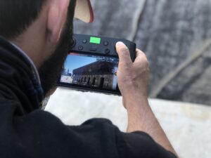
AeroSpect’s drone inspection services are designed to solve many of these challenges. Our drones can be deployed quickly, often with little to no impact on traffic. We operate from safe, ground-level positions and use high-resolution cameras to scan bridge decks, joints, beams, and support structures.
The drones capture close-up visuals of surface wear, joint damage, rusted components, and structural shifts. All images are geo-tagged for precise documentation. This allows engineers to review conditions with clarity and compare them over time.
Drones reduce the need for scaffolding, lifts, or specialized access vehicles. They save time and allow for more frequent inspections without raising operational costs.
Use Cases for Aging Infrastructure
Drone bridge inspections work especially well in situations where access is limited or when structures must remain open to traffic. We’ve helped inspect:
- Historic bridges with unique materials or construction techniques that require non-invasive documentation.
- Post-storm damage assessments, when access is unsafe or delayed.
- Long-term monitoring of bridges showing signs of deterioration, using timestamped images to track changes across months or years.
This flexibility allows municipalities and engineers to inspect more bridges on a faster schedule while improving documentation.
Thermal and LIDAR Options for Deeper Insights
In addition to visual photography, AeroSpect offers advanced scanning options. Thermal imaging helps detect moisture intrusion, delamination, or hidden cracking that may not appear in surface photos. This is especially helpful in concrete structures or enclosed areas.
We also offer LIDAR scanning. This technology uses laser measurements to detect sag, misalignment, and deformation. It is ideal for identifying subtle shifts in older bridges. When combined with 3D modeling, these tools provide a detailed digital twin of the structure—useful for both maintenance planning and retrofitting design.
By combining multiple scanning methods, we help engineering teams gather a full picture of structural health without long delays or multiple site visits.
How Drone Inspections Reduce Risk and Cost
 Drone-based inspections lower the overall cost of bridge assessment in several ways. They require fewer people on-site, reduce inspection time, and remove the need for expensive access equipment. This results in less disruption to road users and lowers the risk of workplace accidents.
Crews remain on the ground while drones collect imagery. This reduces exposure to height-related hazards or traffic areas. Because flight operations are completed in a fraction of the time, teams can cover more bridges on a tighter schedule, all while capturing high-quality data.
In addition, because we work with timestamped data and repeatable flight paths, agencies can build a visual inspection history for each bridge—helping identify long-term patterns of wear or stress.
Why Government Agencies Trust AeroSpect
AeroSpect has worked with public and private clients across New York and beyond. Our pilots are FAA-certified and trained in infrastructure flight planning. We carry full liability insurance up to $10 million and operate with a strong focus on compliance and safety.
Our team includes an ITC Level II certified thermographer for specialized imaging tasks. We understand the documentation and reporting needs of city engineers, DOT teams, and municipal inspectors. All of our data can be delivered in formats that support CAD software, GIS platforms, or public reporting tools.
We also offer both cloud-based and offline delivery methods, so your team can choose what works best for your workflow and recordkeeping systems.
Safer Roads Start with Smarter Inspections
Aging bridges need regular inspection, but that doesn’t mean the process has to be slow, expensive, or risky. Drone bridge inspections give agencies a safer, faster way to collect the data they need. At AeroSpect, we help you monitor your structures with precision and reliability—so you can make confident decisions and plan maintenance more effectively.
To request a demo or schedule an inspection, contact us at info@aerospectny.com or call 718-551-3363. We’ll help you take the next step toward safer, more cost-effective infrastructure management.