Are Drone-Based Facade Inspections Right for Your Facility? A Simple Guide for Engineers and Developers
 Drone technology has changed how building inspections are done. Across the engineering and construction industries, more firms are turning to drone-based facade inspections to save time, reduce risk, and improve documentation. If you’re planning a project, managing an aging building, or working on large-scale developments, you may be wondering whether drone services are the right fit.
At AeroSpect, we’ve worked with engineers, developers, and consultants across the country to deliver inspection data that supports smart decisions. This guide breaks down when and why to consider drone-based inspections.
Why More Firms Are Using Drone-Based Facade Inspections
The demand for better inspection data has grown fast in recent years. Projects are under more pressure to meet deadlines, document progress, and reduce liability. Traditional methods—like scaffolding or rope access—can be slow, expensive, and difficult to scale. Drone inspections offer a faster, repeatable process that gives you a full visual record of your building’s condition.
Drone-based facade inspections help you capture high-resolution data with minimal setup. They provide consistent results, support planning and compliance, and help your team avoid surprises later in the project timeline.
Top Use Cases for Drone-Based Facade Inspection
There are several ways you can apply drone inspections depending on the type of building or project stage. Some of the most common use cases include:
- New Construction: Use drone imaging to monitor progress, document phases, and verify installation quality. Share images with clients, investors, or permitting agencies.
- Existing Buildings: Drones are ideal for Local Law 11 inspections, insurance documentation, or pre-sale condition assessments.
- Large Campuses or Multi-Building Sites: Inspect multiple structures in one flight session. Perfect for hospitals, universities, or residential developments.
- Post-Storm or Emergency Response: After a weather event or structural incident, drone scans help you identify damage without sending crews into unsafe areas.
Drone Data Output: What You Actually Get
AeroSpect offers more than just photos. Our inspections include orthomosaic maps, high-resolution images, and optional 3D modeling. We also offer thermal imagery and LIDAR scans depending on the building’s needs.
You receive a complete, annotated inspection map through our secure online Web Portal. This portal allows you to zoom in on specific points, add comments, and share data with your team. For offline workflows, we also provide delivery by hard drive and export files compatible with your CAD or BIM system.
This kind of output helps teams track changes over time, identify structural concerns, and create a consistent visual history for each project or property.
How Drones Fit Into the Engineering Workflow
Drone-based facade inspections can support different stages of planning and project development. During pre-design, aerial scans help you assess site conditions quickly. Before preparing a repair plan, you can review the current state of the building without relying on limited ground views.
The data also supports RFIs, code review documentation, and early discussions with local permitting departments. Because all images are time-stamped, you can also use the files for long-term studies or compare building conditions across inspection cycles.
In many cases, our clients use drone inspections to shorten planning time and avoid surprises later. It becomes easier to catch problems early and refine design choices with better visual input.
Benefits by Building Type
 Different structures call for different inspection strategies. Here’s how drones work across various building types:
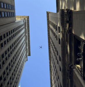
- Skyscrapers: Traditional access methods are expensive and risky. Drones provide full façade scans without scaffolding or rope teams.
- Warehouses and Industrial Buildings: Our drones scan large flat roofs for damage or moisture issues. Thermal imaging also helps detect insulation or HVAC problems.
- Mixed-Use or Commercial Buildings: Easily document multi-elevation structures while coordinating around tenant schedules. Use annotated images to support maintenance requests or landlord reports.
- Drone-based inspections are flexible enough to adapt to each site without requiring major adjustments or access changes. This saves time for engineering and property management teams alike.
Why Choose AeroSpect Over DIY or Lower-Cost Vendors
Not all drone services are the same. AeroSpect is fully authorized to operate in NYC and other major urban markets. Our pilots are FAA-licensed and carry experience working in dense environments with complex airspace rules. We’ve completed inspections for buildings like the Empire State Building, NYSE, and other landmark sites.
We also have a Level II thermographer on staff, certified by the Infrared Training Center (ITC). That means we can provide reliable thermal scans that meet industry standards for insulation and water intrusion assessments.
Unlike some low-cost vendors, we manage every project with professional-grade equipment, secure data handling, and liability coverage of up to $10 million. Our goal is to deliver results that support your engineering goals without creating new risks.
Know Before You Call
If you’re ready to explore drone-based facade inspections for your next project, the first step is simple. We just need the building address, any available elevation drawings, and a clear outline of what you want to inspect. From there, we’ll create a plan that fits your schedule and deliver the output you need.
To schedule a quick consultation, email us at info@aerospectny.com or call 718-551-3363. We’re happy to answer your questions and show you how our service works in real-world conditions.
AeroSpect helps engineers and developers make faster, safer, and better-informed decisions with reliable drone inspection data. Let us know how we can support your team.