January 22, 2026 10 min read
Why Aerial Drone Inspections Are Faster and More Cost-Effective
Set the promise succinctly: cut timelines from days to hours, reduce costs without sacrificing accuracy or safety.
From Weeks of Scaffolds to a 72‑Hour, Code‑Ready Package
On a typical Midtown façade review, the plan is ready—but the swing stage isn’t. Permits lag, a lane closure drags on, and three trades wait for photos that trickle in over four days. Meanwhile, your scaffolding meter runs and at‑height hours stack risk. The worst part isn’t the lift; it’s the delay to a clear answer. Decisions stall because images are scattered, inconsistent, and hard to verify.
We fly the same façade at dawn, capture every elevation in 90 minutes, and never put a person on a swing. Orthos (stitch‑accurate wall maps), 3D, and thermal arrive together, aligned to your drawings. By lunchtime you’ve seen the flagged spalls and cracks; in 72 hours you have a court‑ and code‑ready package. Fewer permits, zero at‑height hours, and decisions the same week.
So why do old methods eat weeks and budget in New York? In the next section, we’ll unpack the hidden costs—scaffolds, lane closures, permits, safety exposure, and data gaps—and show how each maps to a solvable category with drones.
Inspections Control Your Schedule, Budget, and Safety in NYC
You asked why old methods eat weeks and budget in New York. Because inspections gate permits, safety sign‑offs, and lender draws—the work can’t move without them. In 2026, labor shortages, tighter oversight, environmental, social, and governance (ESG) reporting, and inflated equipment rentals amplify every delay. A missed day isn’t just a day. It ripples into reschedules, extended rentals, and postponed payments.
We see it weekly: miss a NYC Department of Buildings (DOB) inspection window and you rebook crews and traffic control. Trades get bumped, lifts sit idle, and you pay daily minimums anyway. Then the Department of Transportation (DOT) lane closure you secured expires mid‑week. Downstream tasks compress into nights or weekends to catch up, which pushes risk and overtime up while quality drops.
Meanwhile, stakeholder pressure intensifies. Owners want clear visuals and traceable decisions, not scattered phone photos. Lenders require date‑stamped documentation before releasing draws. ESG (environmental, social, and governance) reporting adds its own cycles, so you need consistent, repeatable evidence across quarters. Without that, approvals stall, meetings multiply, and schedules slip while everyone waits for proof.
The twist: most of these costs stay invisible until you map them line by line. Let’s surface them now and set up a cleaner path forward.
The Hidden Costs Traditional Methods Bury in Your Project Budget
Scaffolds, cranes, lane closures, and rope access (technicians on lines) look like “means and methods,” but they drive missed permits, overtime, and change orders. You coordinate multiple crews—access, inspectors, safety, flaggers—while insurance exposure climbs with every at‑height hour. One wind hold pushes everything 48 hours. Rebooking a swing stage means resetting tenant notices, DOT control, and DOB coordination. Meanwhile, the data you waited for arrives piecemeal, making it harder to close out RFIs or issue work authorizations on time.
Mobilization fees hit twice when weather or access blocks the first attempt, adding 1–2 extra days of labor and rentals. Return visits to retake missed shots delay reports another 24–72 hours and force additional tenant communications. Rework is common when photos lack coverage or measurement control, so you pay again for coverage you thought you had. Public disruption carries its own price—flaggers, signage, noise complaints, and weekend premiums—while retail tenants push back on partial closures and claim lost revenue.
Use this quick checklist to pinpoint the hidden cost drivers most teams overlook:
- Permit delays cascading into idle crews
- Traffic control and lane closure fees
- Return visits due to missed shots/data gaps
- Premiums for high-risk access methods
- Operational downtime penalties or lost revenue
Stack these together and decisions slip by days—or weeks—while budgets absorb overtime, duplicate mobilizations, tenant appeasement, and administrative churn.
Why the Status Quo Fails in 2026
Access is limited and risky, data is inconsistent, and skilled labor is scarce. You need records that are repeatable, auditable, and shareable across teams, but patchwork fixes add crews, days, and cost. Swapping one access method for another rarely solves the underlying problem: variable coverage and slow, manual documentation. Even with the best intentions, the process remains fragile—one missed permit or weather window and you reset the board.
Coordination overheads balloon as you juggle property management, tenants, safety, flaggers, and inspectors. Weather risk is constant; wind or rain cancels a day and compresses the rest of the week. Subjective assessments—notes and handheld photos—struggle to become measurable outputs stakeholders trust. And when you scale to multiple buildings or repeated cycles, the old approach breaks: every site becomes a one‑off, with no consistent baseline for comparison.
What stakeholders actually need is repeatability and digital‑by‑default deliverables: calibrated visuals, measurable 3D, timestamps, and location metadata that drop into CAD/BIM (design files and building models) and reports without manual stitching. That means consistent coverage across elevations, traceable accuracy, and formats owners, lenders, and regulators accept—so approvals move without another meeting.
So the next step is obvious: adopt a method that compresses field time, reduces at‑height risk, and produces shareable digital deliverables out of the box.
A Faster, Safer Modality Built for NYC
Drone inspections mobilize quickly, work with a minimal footprint, and reposition dynamically around site constraints. In one visit, we capture high‑resolution RGB (standard color imagery), thermal (heat patterns), and LiDAR (laser‑based 3D scanning) aligned to control points. That accelerates processing, so you see preliminary insights the same day and a stakeholder‑ready summary inside 72 hours.
Fewer crews and zero at‑height hours cut safety exposure while reducing downtime for tenants and streets. Coverage is consistent elevation to elevation, so you avoid return trips for missed details. Need a re‑capture after design changes? We can fly again in hours, not days, and drop new data into the same project baseline. Head‑to‑head, this is where drones win.
At AeroSpect NY, we specialize in façades (including FISP—NYC’s Façade Inspection & Safety Program), accident forensics, LiDAR scanning, aerial thermography, and construction progress monitoring. The outcome is simple: safer operations, compliant documentation, and faster decisions—purpose‑built for dense urban sites.
If you’re skimming, here are the core advantages you can expect:
- Hours not days for critical captures
- Little-to-no operational downtime
- Lower access risk for crews
- Richer, measurable digital records
- Fewer mobilizations; fewer surprises
Explore our broader aerial toolset and NYC‑ready workflows in our aerial inspection services overview.
Drones vs. Traditional: NYC Head‑to‑Head
You just saw the toolset and NYC-ready workflows. Now, here's the head-to-head your team will ask for. Read left to right: factor, traditional approach, our drone method, and why it moves your schedule. Each row maps to time, cost, safety, data quality, and downtime. Next, we'll show the real 72-hour project timeline.
| Factor | Traditional methods | Drone inspections (AeroSpect NY) | Why this matters |
|---|---|---|---|
| Time to mobilize | 3–10 days coordinating access, permits, equipment. | Same-day or next-day after filings; typical 24–48 hours. | Shorter lead times protect schedules and lender draws (payment releases). |
| Field time per asset | 4–10 hours per elevation; resets add days. | 20–60 minutes per elevation; 60–80% faster. | More coverage in fewer shifts; decisions the same week. |
| Equipment footprint | Scaffolds, cranes, rope access crews and flaggers. | Small flight team + UAS (uncrewed aircraft system). | Lower disruption, fewer permits, and lower cost. |
| Safety exposure | High work-at-height risk; fall and swing-stage incidents. | Crews remain on the ground; zero at-height hours. | Reduced liability, incident rates, and insurance exposure. |
| Data quality | Handheld photos and notes; inconsistent and incomplete. | High-res imagery, thermal, LiDAR (laser-based 3D); geotagged. | Better decisions, audit trails, and CAD/BIM (design files/building models). |
| Operational downtime | Frequent shutdowns, lane closures, weekend premiums. | Often inspected live; off-hour micro-windows minimize impact. | Avoided revenue loss; happier tenants and retailers. |
| Total cost range | Unpredictable; access gear, overtime, change orders snowball. | Predictable, scoped pricing; fewer mobilizations and returns. | Budget certainty; often 20–40% cost avoided. |
Your 72‑Hour NYC Inspection Plan
You want that budget certainty—and 20–40% cost avoided—without surprises. Here’s how a typical NYC engagement runs, from discovery to CAD/BIM (design files/building models) exports, with real durations you can plan around.
Step 1: Discovery — clarify scope, assets, and constraints (30–45 minutes)
Step 2: Flight planning — airspace checks, safety plan, method statement (same day)
Step 3: On-site capture — flight ops and QA (2–4 hours typical)
Step 4: Processing — orthos/3D/thermal workflows (24–48 hours)
Step 5: Reporting — annotated findings and prioritized issues (within 48–72 hours)
Step 6: Handover — cloud delivery, CAD/BIM exports, and review (same day)
Timelines flex for complex assets, permit steps, or weather, but you’ll still beat legacy methods by days. Up next, quick snapshots show how this plays out across façades, forensics, thermal, and construction.
Where Drones Deliver Outsized Gains
You asked for snapshots—here’s how the 72‑hour workflow translates by sector, with hours‑not‑days capture, fewer disruptions, and double‑digit cost and rework reductions you can defend.
- Construction: monitor progress and QA with weekly flights; reduce rework and reporting time by double digits
- Utilities: inspect 10–20 miles of lines per day; cut patrol costs and improve documentation quality
- Transportation: assess bridges/viaducts without lane closures; compress inspection windows from days to hours
- Renewables: scan PV arrays thermally in a single shift; find hotspots fast with minimal production impact
- Insurance/Forensics: capture scene data rapidly; preserve evidence with accurate, shareable models
- Facilities/Real Estate: document façades and roofs; plan maintenance proactively with measured visuals
If construction is your priority, our drone construction inspection workflows standardize monthly captures and cut report cycles; next, see the same playbook on a New York City façade—zero scaffolds, code‑ready visuals.
Occupied Midtown Façade: 72‑Hour Case
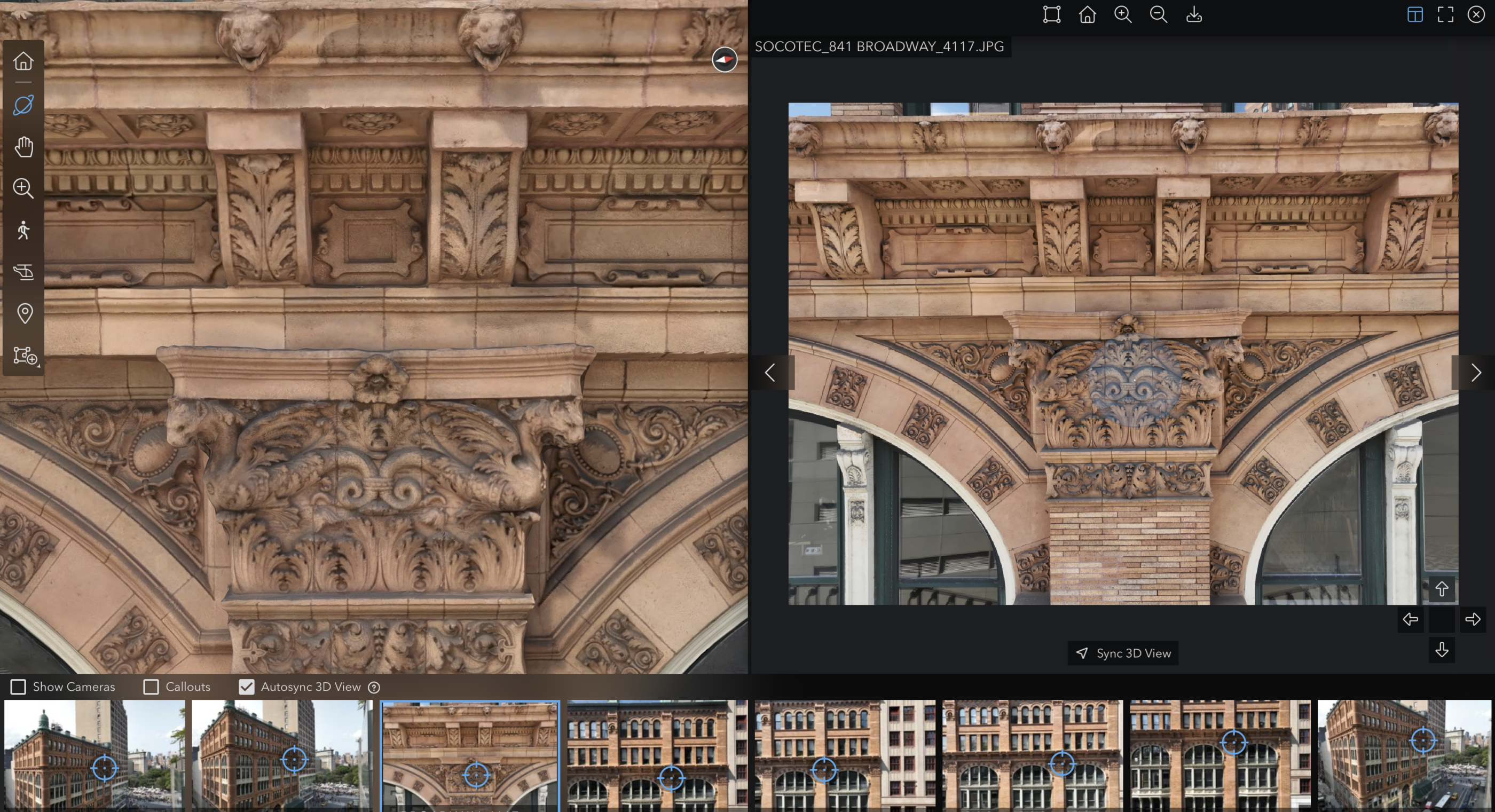
So here’s that same playbook on a live NYC façade—zero scaffolds, code‑ready visuals. An occupied mid‑rise on a crowded avenue, heavy foot traffic, retail open, and a pre‑FISP deadline (NYC’s Façade Inspection & Safety Program). You needed full coverage without shutting down retail or putting anyone on a swing stage. We scheduled dawn micro‑windows, set a brief lane hold (temporary traffic control), and flew RGB (standard color) plus targeted thermal (heat patterns) for moisture flags. Pilots worked from a rooftop and curbside launch with a second aircraft staged for redundancy.
All elevations were captured in 90 minutes with no swing stages or sidewalk sheds. We delivered an annotated orthomosaic (stitch‑accurate wall map), a defect register of spalls, cracks, and efflorescence with location IDs, plus a DWG overlay (AutoCAD drawing file) aligned to control. You saw the flagged items in context, not a folder of close‑ups. Building management and security had tenant notices in place, so operations stayed smooth. A stakeholder‑ready summary went out the same day; the full report landed inside 72 hours, including a FISP‑friendly package.
Outcome: 70% faster than ropes/scaffolds, zero at‑height hours, and about $40K in access and lane‑closure costs avoided. Visual accuracy documented at sub‑centimeter GSD (ground sampling distance) with RMSE (root‑mean‑square error) under 1.5 cm. When design requested a balcony re‑check, we re‑flew a 20‑minute window and dropped new imagery into the same baseline that afternoon, avoiding a return crew and another closure. Up next, the exact files you receive.
Want the same playbook on your building? See our drone facade inspection service and get a tailored 72‑hour plan.
Actionable files in 72 hours
Said yes to the 72‑hour plan? Here’s the package you receive—and who uses it across PMs (project managers), BIM/CAD teams (building models/design files), and LiDAR (laser‑based 3D) workflows this week.
- Orthomosaic: site-wide context for PMs and owners
High-res stills: detail shots for engineers and inspectors - 3D models/point clouds: BIM/CAD alignment for designers
- Thermal maps: anomaly detection for maintenance teams
- LiDAR scans: true-to-scale geometry for as-builts
- Annotated findings report: prioritized punch list for action
Delivered via secure cloud with granular permissions and versioning for time-series comparisons. Exports include DWG (AutoCAD), LAS (point cloud), and PDF. Next, see how we handle safety, airspace, and compliance end-to-end.
Safety, Airspace, Compliance—Handled
You asked how we handle safety, airspace, and compliance end‑to‑end. We own it from planning to landing. All flights are led by FAA Part 107 pilots (U.S. drone license) using documented SOPs (step‑by‑step procedures) and site‑specific risk assessments. We coordinate with NYPD UAS (New York Police Department drone permit), DOB/FISP (NYC façade program), and DOT traffic control. Ground crews only—zero at‑height hours, reducing exposure and liability. Flights over people are evaluated under FAA Categories 1–4 (risk tiers) and flown only when criteria are met. Example: Midtown façade—2 pilots + 1 observer, 20‑minute windows, all ground‑based.
Permits and waivers are filed before we fly: LAANC (real‑time FAA authorization), NYPD UAS permit, DOT lane control if needed, DOB notifications, and night operations (with required lighting/training). We draft a communication plan for building staff and tenants—who’s notified, when, and how. Emergencies are drilled: lost‑link procedures, safe landing zones, and kill‑switch criteria documented in the site plan. Evidence is preserved with chain‑of‑custody: time‑stamped capture logs, cryptographic hashes (file fingerprints), read‑only archives, and access logs—court‑ready for forensics or compliance reviews.
Established in 2018, we operate in NYC’s most regulated settings and follow FAA, NYPD, DOB, and DOT rules on every mission. Part 107‑certified pilots, documented safety plans, and insured operations back each flight. With risk handled, we keep it quiet and quick—next, the downtime gains.
Lower Footprint, Near‑Zero Downtime
With risk handled, what do downtime gains look like on a live building? We arrive with a two‑person crew, one vehicle, and a small kit—no sidewalk shed, swing stage, or generator. Flights run in 20–30‑minute off‑hour windows, so retail stays open and lobbies keep moving. Because the site stays live, you skip lane closures and weekend premiums, and you support ESG (environmental, social, and governance) goals with fewer vehicle miles, lower noise, and less waste.
The environmental footprint is small and measurable. Typical missions need one hybrid SUV, no lifts, and 60–80% fewer vehicle hours than scaffold or crane setups. Acoustic impact stays low—under 70 dB (decibels) at the curb—so neighbors barely notice. Most important, revenue keeps flowing: hotel check‑ins, restaurants, and office access continue while we work, preserving sales and avoiding penalty charges for shutdowns.
Get Your 72‑Hour Plan
If keeping revenue flowing matters, here’s how you start: five steps. We handle permits, safety, and coordination while you approve scope and timing.
Step 1: Share goals, drawings, or prior reports — Send address and deadlines; 10–15 minutes lets us draft a tailored scope.
Step 2: Define assets, access windows, and constraints — We confirm elevations, roof zones; propose dawn or off‑hour windows to minimize impact.
Step 3: Approve scope and flight plan with safety notes — We deliver scope and timeline; you approve or adjust quickly.
Step 4: Capture + rapid processing with QA checkpoints — On‑site flights in micro‑windows; same‑day quality assurance (QA) checks and 24–48‑hour processing.
Step 5: Review findings, next actions, and schedule follow-ups — We review a 15‑minute summary, assign owners, and set any re‑capture windows.
Want a no‑pressure scope? Send the address and deadline—we’ll return a tailored plan, permit path, and 48–72‑hour deliverables. If your site has constraints, we’ll propose hybrid options that still deliver a unified report.
When Drones Aren’t the Answer—What to Do
You mentioned constraints—good call. In NYC, 25–30 mph gusts, RF (radio frequency) glare, or no-fly zones happen; this checklist shows how we pivot fast and still deliver a unified report.
- Heavy winds: reschedule windows or select heavier platforms
- RF-dense urban canyons: preflight surveys and manual redundancy
- Indoor/confined spaces: use caged UAVs or ground robots
- Highly sensitive sites: stakeholder coordination and DOC review
- No-fly airspace: secure permissions/waivers or alternate methods
KPIs That Prove It
Whether no-fly airspace forces waivers or a hybrid method, you still need a scoreboard. This table lists common KPIs, typical before/after ranges, how to measure them, and targets—e.g., façades dropping from 7 days to 72 hours.
| KPI | Before drones | After drones | How to measure | Target range |
|---|---|---|---|---|
| Time to first insights | 5–10 days | Same day to 72 hours | Kickoff to report timestamp | 60–90% faster |
| Direct access cost | High (scaffolds/cranes) | Low (drone team) | Vendor invoices | 30–50% lower |
| Rework and change orders | Frequent | Reduced | Issue logs vs. as-builts (final drawings) | Down double digits |
| Record completeness | Variable | High, repeatable | Shot lists + deliverable audits | 90%+ completeness |
| Safety exposure hours | High | Low | JHAs (job hazard analyses) and incident logs | -70% or more |
| Downtime hours avoided | Low | High | Operations logs + production data | Material reduction |
Request Your NYC Drone Scope
If material reduction and 60–80% faster capture are on your scorecard, send your address, asset list, and any drawings. We’ll return a tailored scope, permit path, and a 48–72 hour timeline—faster, safer, and precise enough for code or court. No scaffolds.
Prefer a quick call? In 15 minutes we’ll confirm elevations, access windows, and deliverables, then pencil a capture window within 2–3 days. Most façades get a stakeholder‑ready summary in 72 hours and full files by day five.
Want proof before you commit? Ask for an anonymized façade report or forensic package with accuracy notes, timestamps, and chain‑of‑custody details.
About AeroSpect NY
Before you request your drone inspection scope, here’s who you’ll work with. AeroSpect NY has focused on urban inspections since 2018: façades and FISP (NYC’s Façade Inspection & Safety Program), accident forensics, LiDAR (laser‑based 3D scanning), aerial thermography (heat‑pattern imaging), and construction progress monitoring. Our FAA Part 107 pilots (U.S. drone license) pair advanced imaging with strict safety SOPs (site‑specific procedures) built for regulated NYC sites. We plan around NYPD UAS permits (city drone approvals), DOB (Department of Buildings) / DOT (Department of Transportation) coordination, and airspace, then capture high‑resolution, repeatable visuals without scaffolds or swing stages. The result is faster insight, lower risk, and decisions you can stand behind.
You care about reliability, not hype. Since launch, we’ve completed hundreds of NYC missions with a safety record of zero at‑height hours and insured operations (COI naming your entity on request). Typical captures run 60–80% faster than scaffolds, with stakeholder‑ready summaries inside 72 hours and full deliverables by day five. Accuracy is documented: RTK/PPK (satellite correction methods) and ground control yield sub‑centimeter GSD (pixel size) and reported RMSE (error) in every package. For forensics, we maintain chain‑of‑custody with timestamps, hashes (file fingerprints), and access logs. Bottom line: predictable timelines, auditable data, and a team that navigates NYC permits so your project stays on schedule. See the sources below.
Standards and Sources
As promised, here are the sources we rely on—FAA (Federal Aviation Administration), OSHA (Occupational Safety and Health Administration), NIST, ASCE, and DOE/NREL—to validate safety, accuracy, and efficiency for your due diligence.
- FAA: Part 107 guidance and waivers
- OSHA: Work-at-height safety references
- NIST: UAS data and measurement frameworks
- ASCE: Infrastructure inspection best practices
- DOE/NREL: PV thermography guidelines
Get Expert Help
Let's discuss your site and timeline
Message Sent!
Thank you for reaching out.
We'll get back to you shortly.